Update: 8:45 p.m.:An Evacuation Alert was issued for 29 properties by Cariboo Regional District at the Emergency Operations Centre (EOC) for the 150 Mile House – Borland Creek area due to flooding in the area Wednesday afternoon, April 22.
Read More: Cariboo Regional District issues evacuation alert for some 150 Mile House properties
Meanwhile, access for residents only has been gained via a temporary road in place which goes through the 150 Mile House Ranch, out behind Chemo RV onto Highway 97.
Read More: Temporary road in place for 150 Mile House residents impacted by flooding
Update 2:50 p.m.: The Cariboo Regional District will be providing new information this afternoon (Wednesday, April 22) for residents impacted by this week’s flooding.
In particular, communications manager Chris Keam said there will be no shelter in place order issued Wednesday as a result of the flooding. Keam said the situation is quickly evolving and they will be getting information out to residents as soon as posssible on next steps.
For immediate assistance or in emergency road conditions, residents can contact Dawson Road Maintenance 24/7 at 1-800-842-4122. The Cariboo Regional Distrrict’s Emergency Operations Centre has been activated and the CRD Emergency Information Line at 1-866-759-4977.
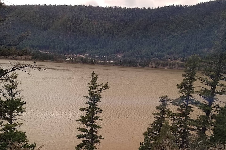
The San Jose above Borland Creek is flowing at approximately a 100-year flow at 30 m3/s with the rate of rise easing, according to the BC River Forecast.
The forecast centre is maintaining a flood warning Cariboo and Chilcotin (Fraser Plateau) including tributary rivers and streams around Williams Lake, Quesnel, Alexis Creek, Anahim Lake, Cache Creek and surrounding areas as well as the Nazko River and West Road River as of Wednesday morning, April 22.
The River Forecast Centre is also maintaining a flood watch for tributary rivers and streams around Chilako and south-west of Prince George.
“Temperatures through the region peaked on Monday and experienced a slight easing on Tuesday, with daytime highs in the 14C to 15C range around Williams Lake and Prince George, and up to 22C south around Ashcroft and Cache Creek. Overnight temperatures have risen to above freezing and as high as 10C overnight in Ashcroft. Weather over the next couple of days is expected to be more unsettled with showers,” stated the centre.
The River Forecast Centre stated the snowmelt rates have been elevated, with 10-25 mm of melt a day being observed at regional automated snow weather stations. The decrease in daytime high temperatures is being offset by the high overnight temperatures resulting in continued high snowmelt rates.
River levels have continued to rise, with some signs of reaching or approaching peak level in some areas, while other areas continue to see rises.
Current reported river conditions as of 6 a.m. Wednesday, April 22 include:
West Road River near Cinema (Water Survey of Canada gauge 08KG001) appears to have an easing in the rate of rise, with the potential for additional rises over the next two days depending on weather.
Baker Creek at Quesnel (08KE016) is flowing at approximately 110 m3/s (between a 10-year and 20-year flow) and rising
San Jose above Borland Creek (08MC040) is flowing at 30 m3/s (approximately a 100-year flow) with the rate of rise easing.
Bonaparte River below Cache Creek (08LF002) is flowing at 50 m3/s (five-year to 10-year flow) and rising.
“While there are early signs that river levels may be approaching or at peak levels, showers and on-going snowmelt over the next couple of days should keep river levels high and may lead to additional rises. Current modelling is indicating the potential for additional rises through the end of this week.”
The public is advised to stay clear of the fast-flowing rivers and potentially unstable riverbanks during the high-streamflow period.
More to come.
Original:
Hundreds of residents in the 150 Mile House area south east of Williams Lake are being asked to shelter in place Wednesday morning as flood waters continue to rise and cut off access to properties.
As of Wednesday morning, the Cariboo Regional District’s communication manager Chris Keam said 246 dwellings were impacted.
Road crews have been working around the clock for days trying to keep up with the flooding, which has hit areas in all regions of the Cariboo Chilcotin.
Read More: “Borland Creek has never been has high as this’: 150 Mile fire chief’s property flooded
Information from local residents at Horsefly as of 10:10 a.m. Wednesday, April 22:
Horsefly road at Beaver Valley junction, flooded across road, single lane traffic, truck or SUV only.
Beaver Valley Road, CLOSED, washed out at six kilometres and 24 km/Choate Creek
Bells Lake road, CLOSED, washed out at three km, 7.5 km and the 10 km.
Cave Road, CLOSED, washed out. Old Ford Road is open so the locals can get out.
Gravel Creek Road, CLOSED
Horsefly/Quesnel Lake Road, water issue at one km, large hole on lower side of the road, water is not flowing across any more.
Spokin Lake Road, CLOSED, washed out at 10 km, is being worked on.
Mile 108 Road, some pooling water and soft spots from frost but in good shape.
More to come.
Do you have a comment about this story? email:
editor@wltribune.com
Like us on Facebook and follow us on Twitter.