The following is the latest information from the Cariboo Regional District regarding the Mount Polley Mine tailings breach:
Government and CRD officials continue to work together to address the breach at the Mount Polley tailings pond, to test the local drinking water to determine if it is safe for locals to drink or bathe in and to help ensure the safety and well-being of local residents.
This factsheet will be updated daily with the latest information available.
New today:
1. Water samples taken by Ministry of Environment (MoE) staff from the southeast corner of Polley Lake on Aug. 7 and 8 have been tested and results are very close to historical levels taken prior to the Aug. 4 tailings pond breach.
2. As a result of this latest testing, Interior Health (IH) has further rescinded its water use advisory. The “Do Not Use” advisory will remain indefinitely for the impact zone directly affected by the breach, which includes Polley Lake, Hazeltine Creek, and where Hazeltine Creek runs into Quesnel Lake, extending to 100 metres from the edge of the sediment deposition.
3. Additionally, water samples taken on Aug. 7 from three locations in Quesnel Lake and along Quesnel River have been analyzed with most of the parameters being well within provincial and federal drinking water guidelines.
4. Following consultation and discussion with a number of partners on the human health risks associated with eating fish, IH’s Medical Health Officer (MHO) has deemed all fish outside of the revised Aug. 12 “Do Not Use” water advisory as safe to eat. Individuals should refrain from eating fish from the remaining impact zone, as noted above.
5. MoE staff, Cariboo North MLA Coralee Oakes and Cariboo-Chilcotin MLA Donna Barnett delivered hard copies of analytical data with summary memos, news releases and IH’s rescind order to the Town of Likely. The information package was handed to a number of residents and placed at the following locations: Valley General Store; Canada Post Office bulletin board; Likely Lodge Diner; Cedar Point Provincial Park bulletin board; and the museum.
6. On Aug. 12, MoE field staff obtained water samples at the discharge point from Polley Lake into Hazeltine Creek. Sediment samples were also collected from the tailings pond breach area and Hazeltine Creek.
7. The CRD will be posting restricted access signage today for the area identified in the Official Order of Restricted Access.
8. Based on the water quality testing results, Fisheries and Oceans Canada has re-opened the Chinook salmon fishery on the Quesnel and Cariboo Rivers. See the notice here: http://www-ops2.pac.dfo-mpo.gc.ca/fns-sap/index-eng.cfm?pg=view_notice&DOC_ID=162464&ID=all.
New Aug. 12:
1. The Ministry of Environment received water samples from Polley Lake late last night and have shared them with Interior Health (IH). The health authority is reviewing them closely and is expected to provide an update on water quality and the water advisory in place later today.
2. The Cariboo Chilcotin Coast Tourism Association will highlight the tourism stories of the region in meetings with international travel media next week at the GoMedia Marketplace in Winnipeg. Hosted by the Canadian Tourism Commission, this is the largest annual travel media event in Canada where over 100 Canadian tourism marketers and businesses meet with over 300 international media who focus on travel.
New yesterday, Aug. 11:
1. Independent Ministry of Environment sample results from Polley Lake are expected late today. Government will provide an update as soon as these results are received and reviewed. If results align with those of Imperial Metals’ samples, Interior Health (IH) may consider a full or partial rescind of the drinking water advisory.
2. First Nations Health Authority (FNHA) staff, including those from Environmental Health, are developing a sampling program to address the concerns of immediate consumption of fish, and will focus on salmon tissue sampling in the confluence areas of the Quesnel and Fraser River.
3. Mt. Polley Mine staff are assisting waterfront property owners with debris clean up.
4. The Conservation Officer Service (COS) delivered and posted an information package in Likely to update residents on the current situation. As updates occur this will continue.
Current situation:
• IH has further rescinded the ban on drinking water following the latest test results. This ban will remain indefinitely for the impact zone directly affected by the breach, which includes Polley Lake, Hazeltine Creek, and an area within 100 metres of the shoreline sediment deposition where Hazeltine Creek runs into Quesnel Lake. **Note: boiling will not help**
• The flow out of the breach has decreased dramatically, but has not completely stopped. Imperial Metals has begun building a temporary dike to stop flow out of the pond.
• Imperial Metals continues to pump water out of Polley Lake both down Hazeltine Creek into Quesnel Lake and back into Wight and Springer Pits, two open pits on the mine. By controlling this water release as soon as possible, it will significantly lower the potential risk of another breach. An uncontrolled release of the stored water in Polley Lake could cause additional risks to human health. As well, it could also result in a possible reinstatement of a broader drinking water advisory.
• The state of local emergency (SOLE) remains in place, giving the CRD exceptional powers in the interest of ensuring public safety. Under the SOLE, the CRD has issued an Order to Restrict Access to the Mt. Polley mine area to help ensure public safety. Authorized mine employees and government officials are exempt. Mt. Polley staff have said they will use their personnel to secure and control entry into the area. The CRD is having signage made that will be posted to mark the area on the ground.
Points that help define this area are located at the north end of Polley Lake, on the Bootjack Forest Service Road, on Gavin Lake Road and two points on the Horsefly Likely Road (Ditch Road). In addition, an area on Quesnel Lake near the mouth of the Hazeltine Creek is also restricted.
• There have been no reports of property damage.
• The portable showers closed last night at 7 p.m. They will remain closed but will be kept on site for a couple of weeks in the event that the situation changes.
• The cause of the breach is still unknown at this time. MoE conservation officers are investigating the breach. Ministry of Energy and Mines (MEM) mine inspectors also are investigating.
• The Province has established regular briefings with First Nations to ensure they are getting as much real-time information as possible.
• The Conservation Officer Service (COS) and MoE staff will continue to deliver and post information packages in Likely to update residents on the current situation as new information becomes available.
• Emergency Management BC (EMBC) and the CRD Emergency Operations Centre (EOC) are working together on response to and recovery of this event, including human impacts. Government resource specialists are in the Likely area to support the EOC in Williams Lake. This team will co-ordinate site-level Provincial response and recovery activities in cooperation with Imperial Metals, the party responsible for site management.
• The CRD EOC has offered that Imperial Metals position a liaison in the EOC in Williams Lake to help improve a coordinated response.
• Mt. Polley Mine staff are assisting waterfront property owners with debris clean up.
• A support team is available to offer local residents emotional support for their unique impacts and coping needs. These trained volunteers provide services to communities affected by emergencies and disasters. The CRD, EMBC and Provincial Health Services Authority are coordinating this effort and will be making more information available to all impacted communities.
• All potable water provided to residents affected has been donated and/or provided by Mt. Polley/Imperial Metals.
• All costs associated with the cleanup of the breach are the responsibility of Imperial Metals, and will not be borne by B.C. taxpayers.
Water sampling:
Water samples taken by Ministry of Environment staff from the southeast corner of Polley Lake on Aug. 7 and 8 have been tested and are very close to historical levels taken prior to the Aug. 4 tailings pond breach.
Results indicate the concentrations of most of the parameters were below both B.C. and Health Canada Drinking Water Guidelines at these sites with slight exceedances of pH and aluminium. Neither of these exceedances present any risk of adverse health effects and are consistent with water quality results from Polley Lake since the late 1980s. These results corroborate similar tests taken from the shore of Polley Lake on Aug. 7 by Imperial Metals.
Additionally, water samples taken on Aug. 7, 2014, from three locations in Quesnel Lake and along Quesnel River have been tested with most of the parameters below both provincial and federal drinking water guidelines.
The exception was a sample taken from a localized area with a visible suspended sediment plume between Hazeltine Creek and Raft Creek. This sample was tested as a worst case scenario. Results showed slight exceedances of phosphorus and aluminium for drinking water and exceedances of copper, chromium, phosphorus and aluminium for aquatic life guidelines. These elevated levels would be expected near an aluminium/copper mine. Additional samples will be collected from Quesnel Lake, as this was the worst case sample and is not representative of the general quality of Quesnel Lake.
These results build on the MoE water samples taken on Aug. 6, 2014, from six locations in Quesnel River and Quesnel Lake, all of which meet provincial and federal drinking water guidelines.
Sampling will take place in safely accessible locations for the foreseeable future. Test results will be shared with local First Nations, First Nations Health Authority (FNHA), IH, and the CRD.
The ministry will continue working with Imperial Metals to develop both short- and long-term plans for further water quality testing. Once sediment sample results are available, the ministry will be able to determine if there is any risk posed by the tailings solids. Long-term monitoring of sediments and identification of any contaminants found in sediment will continue as part of longer term monitoring.
IH will continue to evaluate water samples as they arrive and will update the communities as more information becomes available. There are very few, if any, residents left within the affected area.
The ministry is posting results on its website, including a map of sampling locations: http://www.env.gov.bc.ca/eemp/incidents/2014/mount-polley.htm.
Drinking water advisory:
As a result of the latest water testing, IH has further rescinded its water use ban. A water ban will remain indefinitely for the impact zone directly affected by the breach which includes, Polley Lake, Hazeltine Creek, and on Quesnel Lake, but only the area within 100 metres of the shoreline sediment disposition zone where Hazeltine Creek runs into Quesnel Lake.
The advisory does not apply to people in Williams Lake, Quesnel or other towns along the Fraser River. Fishing by First Nations along the Fraser is also not affected.
For more information and a detailed map, please visit: http://www.interiorhealth.ca/YourEnvironment/EmergencyPreparedness/Pages/MajorEvents.aspx
On Aug. 7, Save-On-Foods, in conjunction with the Canadian Red Cross donated 18,000 500ml bottles of water and 1,440 four-litre bottles of water. These bottles have been distributed to Likely and area residents in need. This donation supplements the work of the CRD, which has organized delivery of water to Likely because the main supplier of bottled water in the area, a small grocery store, could not keep up with the demand.
Wildlife:
The MoE has collected Rainbow Trout and Lake Trout tissue samples from Quesnel Lake from Aug. 8-10 for tissue analysis. While results are expected within two-to-three weeks, efforts are being made to expedite the testing.
The ministry has also taken sediment and plankton samples and are awaiting lab results, expected later this week, to contribute to an assessment of any potential impact to fish and aquatic life. Generally, bio-accumulation of contaminants in fish occurs over a longer exposure time than a few days.
The tailings liquid initially released from the impoundment moved very quickly through the system and was diluted greatly by the water in the lake, the Quesnel River and ultimately the Fraser River. As such, fish exposure was limited and not long enough for uptake into tissues.
Combined with the fact that the water in Quesnel Lake meets drinking water guidelines, it is unlikely there will have been any short-term effects on fish in Quesnel Lake or downstream as a result of this event.
Based on this information, IH and its Regional MHO are confident any fish caught for human consumption beyond the immediate sediment deposit zone are safe to eat. This includes fish from the unaffected area of Quesnel Lake, the Quesnel River, and the Fraser River.
The decision on fish consumption was made after review of water and sediment sample results, which show fish were not exposed to unsafe levels of contaminants from the mine breach. Fish testing currently underway continues to demonstrate no immediate harm to any local fish.
The only reported dead fish is a rainbow trout. It was brought to the ministry's attention on Aug. 6, 2014, following the public meeting in Likely. It was collected by researchers with the University of Northern BC. MoE boat crews have been on the water since Aug. 4, 2014, and they have not found nor received any other dead fish.
If any dead salmon are found in the Fraser River it is likely a result of temperature effects and not contamination from the tailings pond breach. This is not unexpected due to the summer climate in the region.
At the request of First Nations, FNHA is supporting salmon sampling on an interim basis. Collection of salmon will be coordinated with First Nation fisheries departments. A two-to-three day turnaround time is anticipated following the arrival to the lab.
The Ministry of Forests, Lands and Natural Resource Operations (FLNRO) has also made its wildlife team available to investigate reported wildlife concerns.
More information on salmon sampling will be posted at: http://www.fnha.ca/about/news-and-events/news/mount-polley-mine-communiques-and-press-releases.
As well, based on the water quality testing results, Fisheries and Oceans Canada has now re-opened the Chinook salmon fishery on the Quesnel and Cariboo Rivers. See the notice here: http://www-ops2.pac.dfo-mpo.gc.ca/fns-sap/index-eng.cfm?pg=view_notice&DOC_ID=162464&ID=all.
Polley Lake Stabilization Plan:
Sediments and debris have created an unstable blockage at Polley Lake that has resulted in a build‐up of water that could result in a sudden uncontrolled breach. It's necessary to reduce the excess water in Polley Lake in order to stabilize the situation and to avoid a potential breach and further release of sediments and debris into the surrounding waterways.
The potential for rain could further increase water levels in Polley Lake and outflows from Hazeltine Creek. A controlled release of excess water with a discharge pipe will help to stabilize the area and reduce the risk of a breach and further sediments reaching Quesnel Lake. Imperial Metals has completed constructing a discharge pipe to Hazeltine Creek downstream from the tailings blockage and is now pumping water from Polley Lake.
The pumps are operating at their capacity, pumping approximately 8,000 gallons per minute. The water will then flow downstream into Quesnel Lake where it will be tested daily.
Once the water level is reduced to a safe level, technicians will commence water and sediment sampling in Hazeltine Creek. The map of the discharge pipe route is available at: http://www.env.gov.bc.ca/eemp/incidents/2014/mount‐polley.htm.
Currently, water is also being pumped out of Polley Lake by a second, smaller system, into Wight and Springer Pits, two open pits on the mine, at a rate of approximately 800 gallons per minute.
On-the-ground provincial support:
Currently, there are more than 50 provincial government staff on the ground in Williams Lake, Likely and in the surrounding areas. They are all supporting with the investigation of the incident and recovery of the area.
They include biologists, conservation officers, mine inspectors, emergency management specialists, health protection officers, debris disposal workers, communications officers, and community support and job assistance workers.
Environment Canada has an additional five staff on site in the area. As well, EMBC has activated both its northeast Provincial Regional Emergency Operations Centre (PREOC) and the Provincial Emergency Operations Centre (PECC) in support of this incident. There are three staff at the PREOC in Prince George and another seven staff activated at the PECC in Victoria to support all the work being done in the Cariboo.
Pollution abatement order:
On Aug. 6, the MoE issued a Pollution Abatement Order (PAO) to Mt. Polley Mining Corp. This order required immediate action to stop the further release of mine tailings into nearby waterways and to submit environmental impact assessments and clean-up action plans to the ministry.
It also required the company to submit a written summary of actions taken to stop the release of mine tailings and to undertake preliminary environmental impact assessment and submit an action plan.
Imperial Metals met the Aug. 6 deadline requirements of the order to submit an Action Plan for the Preliminary Environmental Impact Assessment (EIA) and initiate environmental monitoring. The MoE conditionally approved the submission on Aug. 10. Imperial Metals has provided, and will be initiating a plan to stop the flow from the tailings impoundment breach as required by item 1 of the PAO.
The company must also submit a detailed action plan by Aug. 15, and it is required to report weekly on the implementation of action plan measures.
Investigation:
MEM inspectors continue their investigation and are continuing with interviews of mine staff and a review of all applicable documentation on the mine site.
MoE conservation officers are independently investigating the breach. Conservation officers are Special Provincial Constables under the Police Act with a wide suite of powers associated with that designation. Although part of government, the COS is unfettered in its investigations as it has the power to investigate and forward recommendations for charges when warranted directly to provincial crown counsel.
If the public has any information, they are asked to call the Report all Poachers and Polluters (RAPP) line at 1 877 952-7277 or online at: www.env.gov.bc.ca/cos/rapp/form.htm
The inspectors of mines and other agencies will undertake a comprehensive investigation to determine causes for the breach. This will take several months. Lessons learned will be applied to other mines in the province as appropriate.
The Ministry of Energy and Mines is currently working to establish a process for third-party inspections of every tailings impoundment in the province and looking at options to enable an independent investigation of the failure of the tailings pond at the Mount Polley mine. This independent investigation into the breach would be in addition to the ongoing investigation by the Chief Inspector of Mines and the COS.
Dike construction at the tailings pond and other infrastructure:
Work continues on dike construction at the tailings pond breach. The dike is being built in a horseshoe shape just on the inside of the breach to stabilize the tailings material and keep it inside the impoundment when it rains. The company estimates that it will take about three weeks to complete.
Three hundred Imperial Metals employees are working on the dike construction and clean up.
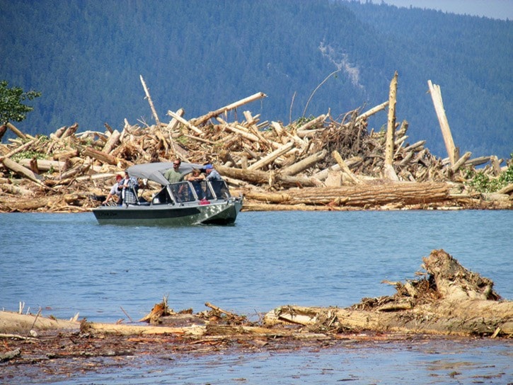
In addition, good progress continues to be made by West Fraser to boom the debris in Quesnel Lake and prevent it from reaching the bridge. The Likely Bridge is not at risk. Most of the large woody debris is now contained within booms and Imperial Metals is working with West Fraser and FLNRO on a disposal plan.
Worker supports:
Staff from the Ministry of Jobs, Tourism and Skills Training (JTST) are in contact with the company to understand current job impacts and to communicate provincial support services. Initial information from the company suggests that, at this time, most of the mine employees remain working.
The JTST Community Transition Manager is on the ground today in Williams Lake and Likely working with the United Steelworkers and the company to coordinate support and gather intelligence on worker and community impacts and services.
Workers who need help connecting with skills training or employment opportunities can contact the local WorkBC Employment Services Centre in Williams Lake at 250 398-5133 to request support.
Tourism information:
All tourism operations in the Cariboo Chilcotin region remain open, operational and ready to welcome guests.
The Cariboo Chilcotin Coast Tourism Association will highlight the tourism stories of the region in meetings with international travel media next week at the GoMedia Marketplace in Winnipeg. Hosted by the Canadian Tourism Commission, this is the largest annual travel media event in Canada where over 100 Canadian tourism marketers and businesses meet with over 300 international media who focus on travel.
In the lead-up to the GoMedia Marketplace, several international tourism media will see the Cariboo Chilcotin Coast as part of a familiarization tour through British Columbia.
People with vacation plans that include travelling to, or through, this area of the Cariboo Chilcotin Coast, the most up-to-date information on the affected area can be can be found on the CRD EOC Facebook page at www.facebook.com/CRDemergencyoperations, the CRD website www.cariboord.ca, or by calling 250-398-5581.
Previous site inspections:
The Mount Polley mine has a valid Mines Act permit and the company has been generally compliant with the Health, Safety and Reclamation Code and their Mines Act permit conditions.
Following reports of a previous breach at the mine, Ministry of Energy and Mines officials investigated an incident on May 24, 2014, and determined this was not a breach. Rather, the height of the tailings pond was above regulation. This occurred in a different area of the tailings pond than the Aug. 4 dam failure.
At the time of the advisory, the distance between the water elevation and the crest of the dam (freeboard) was less than one meter. The tailings pond level returned to authorized levels and freeboard was approximately 2.4 meters when last measured. Mine records show that the operation was carrying out visual dam inspections and measuring freeboard at an acceptable frequency, including daily measurements following the incident.
The Ministry of Energy and Mines conducted a geotechnical inspection at the mine in September 2013, which resulted in no inspection orders related to the tailings facility.
Here is a list of recent advisories to Mount Polley from the Ministry of Environment, only one of which was related to height of the tailings pond. The Ministry of Environment is responsible to ensure no unauthorized effluent discharge from the tailings pond structure:
• May 24, 2014: The ministry issued an advisory to Mount Polley Mining Corporation for exceedance of the height of effluent within the tailings impoundment. The effluent level returned to authorized levels commencing June 30, 2014.
• April 18, 2014: The ministry issued an advisory to Mount Polley Mining Corporation for bypass of authorized treatment works. The site experienced high flows due to spring freshet which caused the pump system to become blocked and resulted in an overflow of effluent to the long ditch. Flow did not reach the creek and was directed into Till Borrow Pit.
• January and April 2012: The ministry issued an advisory to Mount Polley Mining Corporation for not submitting monitoring data for one of the groundwater monitoring wells.
• Aug. 30, 2012: The ministry issued a warning to Mount Polley Mining Corporation for failure to report exceedance of the height of effluent for the perimeter pond. This perimeter pond overflowed, releasing approximately 150 cubic metres of effluent over 13 hours to ground.
As required by the Health, Safety and Reclamation Code for Mines in British Columbia, companies must submit Annual Dam Safety Inspection reports to the Chief Inspector on an annual basis. Inspections of dams by ministry geotechnical inspectors are conducted at a frequency informed by the dam consequence classification that is designated by the dam design engineers in accordance with the Canadian Dam Association Dam Safety Guidelines.
Since the Mount Polley mine was permitted in 1995, there have been 16 geotechnical inspections conducted by ministry geotechnical inspectors. One inspection was conducted each year from 1995-2001 and in 2006, 2008 and 2013. Two inspections were conducted in each of 2005, 2007 and 2012.
In summary, seven geotechnical inspections took place before the mine went into care and maintenance in 2001 and nine geotechnical inspections have taken place since it re-opened in March 2005. The last geotechnical inspection was conducted in September 2013 and resulted in no inspection orders related to the tailings facility.
Here is a historical record of the number of all types of inspections (including geotechnical) each year from 1999 to 2014:
• 1999 - 1
• 2000 - 4
• 2001 – 22 (care and maintenance started September 2001)
• 2002 – 4
• 2003 – 2
• 2004 – 5
• 2005 – 15 (mine re-opened March 2005)
• 2006 – 10
• 2007 – 10
• 2008 – 8
• 2009 – 9
• 2010 – 7
• 2011 – 4
• 2012 – 6
• 2013 – 15
• 2014 (to-date) – 8
Monitoring devices, called piezometers, designed to measure the pressure of water in the dam, did not show any changes in the water pressure before the dam breach. The last piezometer readings were taken on Aug. 2, 2014. The investigation will determine if the piezometers were located correctly.
Incident summary:
Early in the morning of Aug. 4, 2014, the tailings pond dam at the Mount Polley Mine site breached and released an estimated 10 million cubic metres of water and 4.5 million cubic metres of fine sand into Polley Lake. Hazeltine Creek flows out of Polley Lake and the flow of contaminated water continued into Quesnel Lake.
During the initial breach of the tailings dam the bulk of the original flow created an unstable plug at the base of Polley Lake. The balance of the tailings and water went down Hazeltine Creek and deposited at the confluence of the creek and river. Hazeltine Creek was originally about 1.2 metres wide and is now up to 150 metres wide.
Waterways affected by this event include Quesnel Lake, Polley Lake, Hazeltine Creek and Cariboo Creek. Additionally the Horsefly Likely Forest Service (Ditch Road) was washed out at Hazeltine Creek and the Gavin Lake Forest Service Road was washed out closer to the dam breach area.
Additional background:
Early in the morning of Aug. 4, 2014, the tailings pond dam at the Mount Polley Mine site
breached and released an estimated 10 million cubic metres of water and 4.5 million cubic metres of fine sand into Polley Lake. Hazeltine Creek flows out of Polley Lake and the flow of contaminated water continued into Quesnel Lake.
During the initial breach of the tailings dam the bulk of the original flow created an unstable plug at the base of Polley Lake. The balance of the tailings and water went down Hazeltine Creek and deposited at the confluence of the creek and river. Hazeltine Creek was originally about 1.2 metres wide and is now up to 150 metres wide.
Waterways affected by this event include Quesnel Lake, Polley Lake, Hazeltine Creek and Cariboo Creek. Additionally the Horsefly Likely Forest Service (Ditch Road) has been washed out at Hazeltine Creek and the Gavin Lake Forest Service Road was washed out closer to the dam breach area.
The Mount Polley Mine is owned by Imperial Metals and is approximately 30 kilometres from the community of Likely.
The tailings pond at Mount Polley Mine is four kilometres by four kilometres.
This is a large breach and extremely rare. Officials with the Ministry of Energy and Mines do not recall anything of this magnitude in at least the last 40 years.
Other facts:
• The Mount Polley Mine is owned by Imperial Metals and is approximately 30 kilometres from the community of Likely.
• The tailings pond at Mount Polley Mine is four kilometres by four kilometres.
• This is a large breach and extremely rare. Officials with the MEM do not recall anything of this magnitude in at least the last 40 years.
For more information:
A public information line has been set up by the CRD: 250 398-5581. If the public has any information that would be helpful to the investigation into the cause of the tailings pond breach, they are asked to call the Report all Poachers and Polluters (RAPP) line at 1 877 952-7277 or online at: www.env.gov.bc.ca/cos/rapp/form.htm.
Updates will be posted to the CRD’s emergency operations Facebook page, here: http://www.facebook.com/CRDemergencyoperations or on the CRD website at: http://www.cariboord.ca/.
For a collection of documents from government and partners surrounding the Mount Polley breach, visit: http://www.env.gov.bc.ca/eemp/incidents/2014/mount-polley.htm.