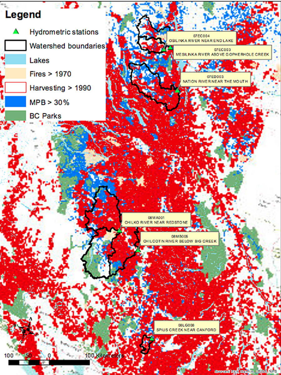
Two large watersheds in the Cariboo Chilcotin are part of a tri-university project studying the affects of wildfires and other disturbances on stream discharge in B.C.’s Interior.
The Chilcotin River below Big Creek and Chilko River near Tsi Del Del (Redstone) are on the list of six large watersheds researchers are focusing on.
Read more: CRD estimates 47 properties impacted by flooding in Chilcotin
Spius Creek near Canford, Nation River near the mouth, Mesilinka River above Gopherhole Creek and Osilinka River near End Lake are also areas the research will look at.
Dr. Thomas Pypker, a professor in the natural resource sciences department at Thompson Rivers University, said they started collecting data about a month and a half ago.
“B.C. has some fairly good long-term stream gauge data dating back, depending on the watershed,” he told the Tribune. “We will be looking at the long-term minimum 40-year trend and discharge.”
Adam Wei, University of British Columbia Okanagan, as the lead, and Stephen Déry from the University of Northern British Columbia are the other two members of the team, and all three will bring along subsequent graduate and undergraduate students to assist.
They have divided up the tasks, which will see Pypker collect and compile river data from the streams.
Déry will gather and compile weather data and Wei has developed a method for analyzing impacts on large watersheds due to disturbance.
An interesting thing about the project, Pypker noted, is that it is looking at large watersheds, larger than 700 square kilometres. An area they are studying in the Chilcotin is 19,200 square kilometres.
Most of the research in the past was done on smaller watersheds, such as 50 hectares, in order to have control to do the studies.
“We really don’t have a very good understanding of how disturbance affects really big watersheds and this research is hoping to fill that hole.”
They are looking at the cumulative affect of disturbance, he explained.
“That would be all disturbance, whether it is wildfire, insect damage, harvesting and land removal for agriculture. We will be looking at how over long periods of time all that has changed stream discharge.”
With so many big wildfires recently, it is also hoped the data collection will inform what threshold the environment can hit in a watershed before it is impacted.
“If 20 per cent of the watershed is cleared or lost due disturbance, in terms of vegetation, how will that then impact stream discharge?” he said. “Right now most management decisions are based upon a 20 per cent threshold based on one study from the mid-90s or 80s. So we have a general lack of information on this.”
Read more: VIDEO: Water Survey of Canada tech checks Chilcotin River water levels July 9
By March or April 2020, they hope to have completed the research.
”It’s a short term, but it’s a bit of a pilot project to see if we can get some interesting results,” Pypker said. “Information collected will be useful for the public and land managers to determine a threshold for disturbance. It impacts how we move forward in terms of how much we can comfortably disturb and have no impact.”
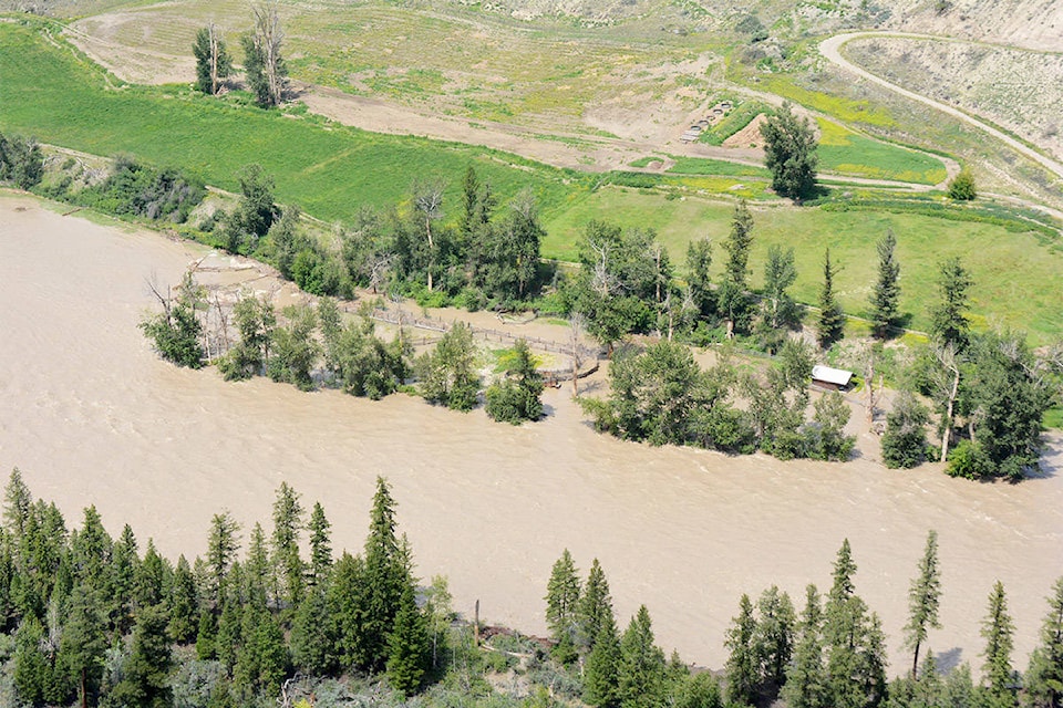
Why flooding happens after wildfires
When trees are lost due to wildfires several things happen that result in possible flooding, Pypker said.
Trees intercept about, ball park, 20 per cent of the incoming rainfall and it never makes it to the ground and evaporates back to the atmosphere.
“That also goes for snow caught in tree canopies. It actually sublimates from a solid state back to a gas.”
They also remove about ball park 40 to 60 per cent of the moisture by transpiration as they are pulling the water out of the ground.
“In a typical watershed, 70 per cent, ball park, goes back to the atmosphere with only 30 per cent making it to the stream. So if you effect the trees you right away increase the amount of water going in because you have 20 per cent, about, going back into the soil.”
As well, the soils are wetter because the trees have not been removing moisture which makes them more prone to have more water go into the stream.
“You also get more snow and deeper snow pack in clearings because of the lack of interception and then when the snow is exposed to sunlight in the spring it melts faster.”
Thirdly, the soil itself becomes hydrophobic sometimes and does not allow water to infiltrate easily, resulting in the water running across the surface as opposed to going into the ground.
“Hydrophobic is variable depending on the fire and how hot it was.”
All those factors can increase flooding, Pypker said.
news@wltribune.com
Like us on Facebook and follow us on Twitter