Flood warnings remain in effect for parts of the Cariboo Chilcotin as of Friday, July 3.
The BC River Forecast Centre is predicting another peak in river levels in the region after the weekend, with continuing warm weather and the return of precipitation at the start of the week combining to deliver increased spring runoff and rainfall.
Horsefly resident Lisa McInnes works at Clarke’s General Store and said when she came to work at 2 p.m. Friday, July 3, there was water up over the road near the bridge that crosses the Horsefly River down to the spawning channel.
“The campground is flooded,” McInnes said.
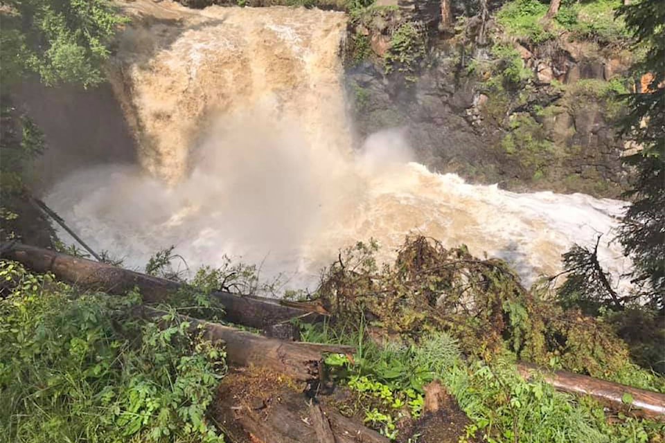
Lonnie Rolph, also from Horsefly, shot a video and took some photographs of Moffat Falls and told the Tribune the creek is high.
There has been flooding between Hooker Road and Ridley Road near Horsefly and on the Black Creek Road in both directions between Kroener Road and Patenaude Bridge, 17 kilometres east of Horsefly.
Near Likely, water levels of Quesnel Lake and the Quesnel River have been flowing at 20 to 50 year levels and the Cedar Point Park began closing some of it campsites a week ago.
Tate Patton, campground manager, said on Canada Day they were down to 10 usable sites out of 26.
“We have campers in the ball field,” he said.
As of Friday, the sun was shining for the first time in many days, but people wanting to camp should call in advance, he added.
Environment Canada is showing a risk of a thunderstorm Friday evening for the Williams Lake area . Saturday is supposed to be mainly cloudy, Sunday sunny with a high of 23C, and Monday a mix of sun and cloud and high of 23C.
A total of 10.3 mm of rain fell on Thursday, July 2.
For the Puntzi Mountain area there is a chance of showers and risk of thunderstorms over southeastern sections for Friday.
Saturday is supposed to be mainly cloudy with highs of 18C and the forecast for Sunday shows a 30 per cent chance of showers and highs of 22C.
In a new release Friday, the Cariboo Regional District encouraged residents to prepare for potential flooding by protecting property and having sufficient food, water, and medications to shelter in place for at least three days, in the event roads or highways are closed due to flooding or landslide. Sand and sandbags are available for free at all CRD volunteer fire halls except for the West Fraser hall.
Residents and property owners who have not done so are asked to register for the Cariboo Chilcotin Emergency Notification System so they can receive a text, call or e-mail regarding evacuation alerts and orders concerning their area.
For Cariboo Regional District information, please visit cariboord.ca or facebook.com/CRDEmergencyOperations or @CaribooRD on Twitter.
To report flooding or landslides call the CRD’s emergency information line at 1-866-759-4977.
To report damaged or washed out roads in the North Cariboo please call EMCON at 1-866-353-3136. To report road conditions in the Central and South Cariboo please call Dawson Road Maintenance at 1-800-842-4122.
Despite a weather forecast calling for sunny summer weather and a break in the rain, the CRD is reminding residents flood warnings and watches remain in effect.
— Dawson Road Maintenance - Cariboo (@DawsonRoadMaint) July 3, 2020
For more information and to view CRD provided resources, please visit our website: https://t.co/R2sZyST2wj
Read more: B.C.’s major rivers surge, sparking flood warnings
With files from the CRD
news@wltribune.com
Like us on Facebook and follow us on Twitter