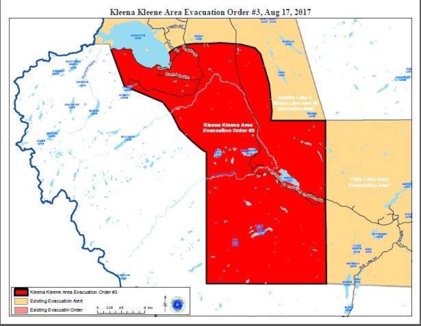
The evacuation order for the area north of Kleena Kleene has been expanded as the Kleena Kleene wildfire is now an estimated 10,006 hectares.
Late Thursday evening, the Cariboo Regional District announced the expanded order which replaces the original order put in place Friday, Aug. 4.
Highway 20 is now closed there with no pilot vehicle access and the RCMP have been accompanying traffic to exit west to Bella Coola, where residents are being asked to register at the Emergency Support Services Centre at 626 Cliffe Street.
On Thursday evening the CRD also expanded an evacuation order east of Nazko which enlarged the existing evacuation order covering the Kluskus, Blackwater, Clisbako and Nazko area order issued on Wednesday, Aug. 2.
The evacuation route for those communities is Nazko Road to Quesnel.
In its latest bulletin the Cariboo Fire Centre said the Kleena Kleene wildfire has moved significantly north on the northwest perimeter past Big Stick Lake due to westerly winds and runs creating rank six fire.
Crews will construct control lines and assess increased aerial attack depending upon visibility to protect Highway 20 and the Kleena Kleene community.
Meanwhile the nearby Colwell Lake Fire is an estimated 4,925 hectares and has moved west to surround Miners Lake except for the northern tip, the CFC noted.
“As per Kleena Kleene our crews will construct control lines and assess increased aerial attack depending on visibility,” noted Colette Fauchon and Kylan McKeen in their latest report.
The Precipice Fire, estimated at 6,506 hectares has had no major growth since Wednesday, they said.