As temperatures rise, the Cariboo Regional District is reminding residents to be prepared for potential flooding, while the B.C. River Forecast Centre is reporting high snowpacks in the major tributaries of the Fraser River.
An April 16 news release from the Cariboo Regional District (CRD) says an above-average snowpack and warm spring weather are bringing high water levels to rivers and streams in the Cariboo. With this in mind, the regional district is reminding property owners to prepare for potential flooding as the snow melts during what is also known as spring freshet.
Unfilled bags and sand are currently available for free at the CRD’s Wildwood and Miocene Volunteer Fire Departments for residents who are experiencing or want to be prepared for flooding. The CRD says it will place bags and sand in other communities depending on need.
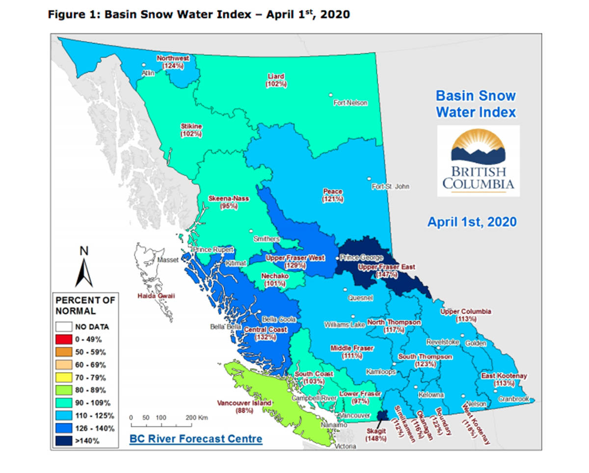
The latest update from the B.C. River Forecast Centre shows the overall snow basin index for the entire Fraser River basin upstream of the Lower Mainland is 16 per cent higher than normal.
The April bulletin, which was released April 8, shows the Upper Fraser East, Lower Fraser, East Kootenay, South Coast, Skagit, Peace, and Liard experienced modest increases in snow basin indices. Most notably, the Upper Fraser East region experienced significant accumulation in the first and last week of March, increasing its snow basin index from 135 per cent of normal (or 36 per cent higher than normal) on March 1 up to 147 per cent of normal for April 1, according to the B.C. River Forecast Centre.
High snowpacks are generally present in the mountainous interior ranges of the province and in the Central Coast region, according to the B.C. River Forecast Centre. Extremely high snowpack (greater than 135 per cent) is present in the Upper Fraser East, Upper Fraser West and the Cariboo Mountains (Quesnel River). Several snow measurement locations recorded an all-time record high Snow Water Equivalent (SWE) for April 1, including Yanks Peak East (Middle Fraser/Quesnel), Horsefly Mountain (Middle Fraser/Quesnel), Upper Longworth (Upper Fraser — East), and Cook Creek (North Thompson).
High snowpacks (greater than 120 per cent) are present in the South Thompson, Boundary, Central Coast (Bella Coola), Skagit and Northwest basins, while moderately high snowpacks (110-120 per cent) are also present in the North Thompson, Upper Columbia, West Kootenay, East Kootenay, Okanagan, Similkameen and Peace.
During freshet, roughly two-thirds of the flow in the Fraser River originates from the Upper Fraser East, North Thompson, South Thompson and Cariboo Mountains, according to the River Forecast Centre.
Snowpack in these areas is very high (131 per cent of normal), and snowpack in unregulated watersheds of the Fraser River upstream of Hope, excluding the Nechako and Bridge systems regulated by dams, are currently among the highest on record, according to the River Forecast Centre.
The April bulletin shows increased seasonal flood risk based on snowpack is present in the Upper Fraser – West, Upper Fraser - East, Cariboo Mountains (Quesnel River), North Thompson, South Thompson, West Kootenay, Boundary, Peace, Central Coast (Bella Coola) and Skagit basins.
Historically, there are only a few years where the snowpack in the major tributaries of the Fraser River have all been high at the same time (these years include 1972, 1974 and 1999), according to the River Forecast Centre.
“Given the importance of the Upper Fraser and Thompson River for the overall freshet flow on the lower Fraser River, this means the seasonal flood risk for the entire Fraser River is elevated,” it states. “Seasonal volume forecasts for select watersheds are also mostly elevated as a result of the seasonal snow pack.”
By early April, nearly 95 per cent of the annual B.C. snowpack has typically accumulated, according to the River Forecast Centre.
“Peak provincial snowpack usually occurs in mid-April,” the bulletin states. “Current short- and medium-range weather forecasts suggest that significant changes to the current snow pack are unlikely. Cooler weather over the next few weeks may delay the onset of melt, which can increase flood risks as more snow melts into May and June.”
The River Forecast Centre says snowpack alone cannot predict whether flooding will occur, and spring weather is also a critical flood risk factor.
“Spring freshet poses a seasonal risk across the B.C. Interior,” it states. “Scenarios that could exacerbate flood risk this year include prolonged cool weather followed by a rapid shift to persistent hot weather (particularly in May), or persistent wet weather or extreme short-term rainfall. Favourable scenarios would include continued dry weather and seasonal temperatures.”
The River Forecast Centre will continue to monitor snowpack conditions and will provide an updated seasonal flood risk forecast on May 8.
READ MORE: Spring flooding a risk as Bella Coola snowpack at 36% above normal
editor@quesnelobserver.com
Like us on Facebook and follow us on Twitter