Cooler temperatures are expected over the next few days as firefighters continue to respond to fires across the 100 Mile Northeast complex in 100 Mile House, which includes fires north of Highway 24 and east of Highway 97. This is the latest update, as of 11:11 a.m. Thursday, July 22.
Flat Lake: mapped at 26,191 ha, as of July 20.
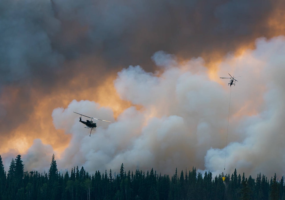
The Flat Lake wildfire saw increased fire activity to the south and southeast Wednesday, due to significant winds, according to BC Wildfire Service’s latest update.
No structures were lost and the fire did not cross Highway 97. However, the highway was temporarily closed from five km south of 100 Mile House to seven km north of Clinton. Smoke from this fire was causing poor visibility and unsafe conditions. The highway is now open but there is a travel advisory in effect and limited visibility with smoke.
Heavy equipment will attempt to gain access and establish indirect control lines on the east flank near Davis Lake Thursday, July 22, working from Bullock Lake Road and moving northwards to the Gustafsen guard. Crews will patrol the transmission line, while an additional guard will be built in the southeast below the Stormy Road.
On the north end, crews will be working to connect existing road systems in the vicinity of Gustafsen and Neilson Lakes, according to the update.
“We are still determining exactly how much rain the fire received but it is thought that it received more than five millimetres, which provides crews a day or two to take advantage of the expected lower fire behaviour to build guard and conduct other operations,” the update said.
There are 15 helicopters available to continue to action the fires within this complex with bucketing activities. Structural protection specialists continue to support the residences and properties on Bullock Lake Road. There are currently 81 firefighters, 53 pieces of equipment, 22 structural protection personnel.
Evacuation order and alerts issued by the Thompson-Nicola Regional District and Cariboo Regional District remain in place, as does an evacuation alert for the District of 100 Mile House.
Canim Lake: mapped 2,487 hectares
Crews continued to monitor the fire overnight following work to establish containment lines around the fire, including black lining and wetlines. BC Wildfire Service said there continues to be fire activity well within the containment lines.
Hand ignitions will be conducted in areas where the fire did not come down to the guard and crews will establish a 10-foot blackline where the fire did come down to the guard. Crews will continue to patrol areas that have been blacklined. Heavy equipment is working to finish the south guard.
The fire remains out of control. An evacuation order issued by the Cariboo Regional District for the south side of Canim Lake remains in place. The north side of Canim Lake remains on Evacuation Alert.
Succour Lake: estimated at 529 ha
BC Wildfire Service will continue to monitor this fire and respond if necessary. However, the fire has seen minimal growth and is not currently threatening any communities or access roads. Evacuation alerts for the north side and west side of Canim Lake remain in place.
FIRE: one km NW of Irish Lake near Lone Butte
This wildfire, located 1km NW of Irish Lake near Lone Butte, is currently being held meaning that the fire is not likely to spread beyond existing boundaries. This fire continues to produce smoke as areas within the fire perimeter continue to burn, however but this is normal fire behaviour and is not cause for concern.
A sprinkler line was effective. BC Wildfire Service has been supporting the Lone Butte Fire Department in responding to this fire and continue to monitor it.
Other fires:
A southwest of Deka Lake is being held, while one southwest of Judy Lake remains out of control. The following fires are under control: 1.3km NE of Wilcox Lake, East of Ryall Rd, Dombey Lake east, Dombey Lake south, Duckling Lake south, Howard Lake, Southeast end of Lang Lake, End of Horse Lake Rd North, East of Fiset Lake, 2.3 km north of Deka Lake, Schoolhouse Lake Park.