By 1860, the numbers of goldseekers making their way into the Interior of British Columbia and the amount of gold which was coming out of the region convinced Governor James Douglas that better access was necessary. The government had a huge debt load, and a good road to the Interior would allow for better and more accurate collection of taxes and fees, more efficient travel to the goldfields for supplies, quicker and safer travel, and better communication.
Governments never make decisions quickly, so it was not until the spring of 1862 that Gustavus Blin Wright was contracted to build a wagon from Cayoosh (Lillooet) to Cut Off Valley (Clinton), with an option, if the job was satisfactory, to extend the road all the way to Mud (McLeese Lake). Wright, a native of Vermont, was a 30-year-old engineer and entrepreneur. He had been hired previously by the colonial government to provide a professional appraisal of the Harrison to Lillooet trail, and his work was impressive.
The new wagon road was to be overseen by the Royal Engineers, who would survey and help clear the route, inspect all bridges, ensure specifications were met, approve the final results, file regular reports, and measure the completed mileage. The road was to be: “the uniform width of 18 feet, according to specifications and directions from time to time … along a route approved by the Chief Commissioner, but selected, in the first instance, by the contractor.”
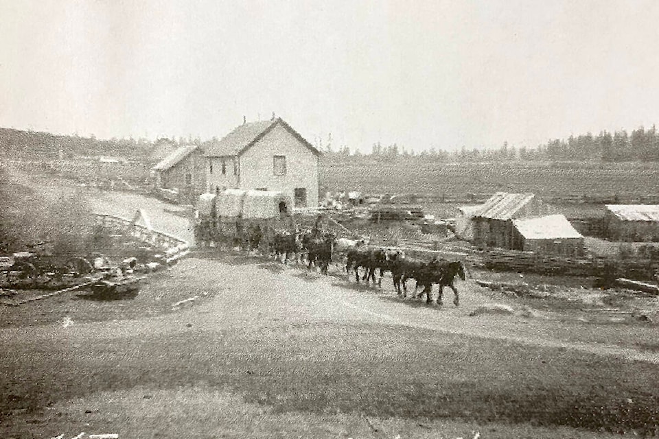
Wright had up to 800 men working on this project. They were paid $1.50 per day for Caucasian workers and $1 per day for Chinese and Indigenous workers. The men were organized into specialist work crews — ground clearers, road builders, ditch diggers, and bridge and culvert teams. No mechanical equipment (other than wheelbarrows) was used. Men had to carry their own tools, which included picks, shovels, mattocks, sledge hammers, and axes. Blasting powder, ropes, and other essential materials were carried on a mule-drawn work wagon. The men worked from dawn until dusk, six days a week.
The road was begun in April 1862, and by mid-August, it was completed through to Clinton. Wright then signed an agreement to extend it to Alexandria, and by Nov. 9 of that year, when the road-building season ended, his advance crews had reached the 127 Mile mark, just north of Lac La Hache.
Construction of roads in those days was financed by large cash subsidies from the government to the builders or by land grants in lieu of cash payments. Builders could also pre-empt land along the way, build bridges at their own expense and set up toll stations, and route the road past already existing farms and stopping houses (for a financial consideration from the owners). Wright was very astute, and did all of these things. By the time the Cariboo Wagon Road was completed, it passed by 43 Mile House (Clinton), 70 Mile, 83 Mile, 93 Mile, 122 Mile, 127 Mile, 150 Mile and 164 Mile (Deep Creek). In each of these places, Wright had either pre-empted the land or owned a major interest in a roadhouse there. Thus, the road was not a straight one. It meandered through the Interior plateau, reflecting the opportunities Wright had taken advantage of, or the financial arrangements he had made with existing landholders and businessmen.
In the spring of 1863, the plan, as envisioned by Captain John Grant of the Royal Engineers, was to have the road swing down from Lac La Hache to the San Jose River and follow its valley all the way to the small but growing village of Williams Lake. Then, the road was to go north, parallel to the Fraser River, up to Fort Alexandria.
Wright realized that there would be some major problems with this route. The high cliffs and deep coolies beyond Williams Lake would require some major and expensive blasting, the sandy soil would need extensive cribbing, and several bridges would have to be built. As well, there was virtually no suitable pasture or water for the pack and draft animals.
Wright’s alternative was to run the road alongside the San Jose River from 127 Mile to 137 Mile, then swing to the northeast over to 150 Mile House. It just so happened as well, that Thomas Davidson, who owned the Lake Valley Ranch and roadhouse at 150 Mile was an old business partner and friend. From 150 Mile, Wright would run the road northward, over Carpenter Mountain to Mountain House, then east through Deep Creek and over to Soda Creek on the Fraser River. This route was well used already by packers and had an abundance of feed and water along the way. The terrain was much easier for road-building, and the distance was eight miles shorter than the Fort Alexandria plan. Wright did not choose to disclose, however, that he owned a half interest in the farm and roadhouse at Deep Creek, as well as a half interest in the new riverboat Enterprise, which was currently under construction at Soda Creek.
In early April, 1863, Wright and Sgt. McMurphy of the Royal Engineers paid visits to Davidson at 150 Mile and to Thomas Menefee at Williams Lake, the owner of two roadhouses in the area. The two road options were explained, and Wright requested that Menefee and the businessman of Williams Lake give him $15,000 to help finance the very expensive route north. In exchange, the road would be routed right through the small village (which was located where the dairy fields are today). Menefee angrily refused, saying that he would not be held to ransom for a publicly funded road. Davidson, not surprisingly, was quite willing to work out a financial arrangement with Wright, and the easier Deep Creek route was chosen.
When the people of Williams Lake found out that the new road was going to bypass their community, there was widespread anger, and disbelief. When they discovered that Wright had holdings at Deep Creek and was involved in the building of the Enterprise, they were outraged. Letters of protest were sent to Victoria, and threats of violence and sabotage were made to the roadbuilder.
For several weeks there was a stand off between Captain Grant and Wright over which route to take. Each demanded that the other listen to reason and change his mind. Finally, Wright made a trip to Victoria to appeal in person to Colonel Moody, the Chief Commissioner of Lands and the Lt. Governor of B.C. Moody sent a special envoy, St. James Lindsay, to examine both routes. Lindsay sided with Wright, and official approval for the Deep Creek route was granted.
Thus, the original village of Williams Lake was doomed to become a little used backwater. It gradually went into a decline. As the gold rush moved on, the demand for the supplies from farms in the area diminished and fewer and fewer travellers passed through on their way to or from the goldfields.